Showing posts with label photography. Show all posts

Wednesday, December 31, 2025

Himeji Castle

Of all the cool, interesting or delightful sights I saw during my travels in 2025, I'd have to put Himeji Castle at the top of my list. Granted, everything we saw during our trip to Japan last summer was amazing, but the Shogun-era castle was truly unique in terms of its history and its beauty.  

Corinne and I took the Shinkansen from Osaka - it was her first experience riding the bullet train - to Himeji, and we then took a short bus ride from the train station to the entrance to the castle grounds. It was very hot the day we visited, so rules prohibiting drinks within the castle were waived (we were actually encouraged to bring water with us during our walk through the castle, which was a kind and thoughtful gesture on the part of the staff). The castle grounds were enormous, with many interactive exhibits in both Japanese and English. There was also a lot of climbing involved, both around the castle grounds and within interior spaces such as the Main Keep. The entrance fee of ¥1,050 per person (about $6.70) was a true bargain, given how much there was to see!

Himeji Castle dates back to 1333; the current structure largely built between 1581 and 1618. Although much of Himeji was reduced to rubble by American bombers during World War II, the castle itself was largely untouched. It has withstood frequent earthquakes over its centuries of existence as well.

While the castle structure is original, it underwent an extensive restoration between 2009 and 2016. The Main Keep (the largest and tallest part of the castle) was essentially dismantled and reassembled. The castle's roof was completely restored, its walls were re-plastered, and earthquake-resistant structural elements were added. 
A closer look at the castle's architecture. The castle had to be built with withstand both invaders and earthquakes; that this was accomplished with such beauty is remarkable.

The view from the top of the Main Keep, looking back at Himeji's train station. The top of the Main Keep reaches an elevation of 302 feet, providing spectaular views of the surrounding city. 


A view from inside the Main Keep, showing the centuries-old wood craftmanship. In order to protect the castle's wooden floors, and in keeping with Japanese tradition, you are required to take your shoes off before entering the Main Keep.


Another view of the Main Keep's interior, showing the castle's traditional wood architecture. The Main Keep has seven stories, including a basement. A small Shinto shrine is located at the keep's top level.
The Bizen Bailey (a fortified courtyard) in front of the Main Keep was the perfect place for Corinne and me to take a picture. Himeji Castle was registered as a UNESCO World Heritage Site in 1993.
A pathway leading to the Taiko (Drum) Tower just outside of the Bizen Bailey. Note the loopholes, where archers or gunmen could fire upon invaders, to the left. Himeji Castle's defenses are impressive, but it was never attacked.
After visiting the castle, we went next door to see the Koko-En Garden. The garden was built in 1992 to commemorate Himeji's 100th anniversary as a municipality and was delightfully serene and beautiful. 
Koko-En Garden is divided into separate sections with different landscaping themes. A tower along the castle's West Bailey wall can be seen peeking out above the trees to the right. 

The castle at twilight, as seen from Himeji's train station. After leaving the castle and adjacent garden, we walked back to the station, stopping at a small restaurant for amazingly delicious Tonkatsu, and then took the Shinkansen back to Osaka. All of our days in Japan were wonderful, but Corinne and I agree that the day we visited Himeji was our favorite. 

Even though my trip to Japan was months ago, I'll be able to enjoy Himeji Castle anytime I want. This is because Corinne got me the Himeji Castle LEGO set for Christmas!

Wednesday, November 06, 2024

Philadelphia

A couple of weeks ago, I traveled to Philadelphia, Pennsylvania for a conference, It was my first trip to the City of Brotherly Love and the weather was excellent for some picture-taking:

Logan Square, looking down Benjamin Franklin Parkway towards City Hall


Market Street, with the iconic PSFS building in the distance


Historic churches and modern skyscrapers in downtown Philadelphia


Independence Hall, where the Declaration of Independence was signed


The Liberty Bell, on display across the street from Independence Hall


Reading Terminal Market, a former train station featuring a variety of restaurants and shops


Speaking of trains! Jefferson Station is served by SEPTA's extensive Regional Rail system


Going forward, I need to make a point to either come in to town the day before a convention or stay a day after so I can spend more time exploring. It's kind of hard to sight-see and attend seminars at the same time...

Wednesday, October 09, 2024

The stars at night are big and bright...


Taken at Corinne's aunt's farm outside of Mexia, Texas last weekend. I must say that the "Night mode" on my iPhone 14's camera works pretty well... 

Wednesday, September 18, 2024

Perugia's Minimetrò

One more post about our Thanksgiving trip to Italy almost two years ago. This one is inspired by a YouTube video I recently came across.  

The Italian town of Perugia, where Corinne and I stayed while visiting her nephew and niece-in-law over the holiday, is served by a automated people mover system called the "Minimetrò." Corinne and I rode the Minimetrò during our stay in Perugia, and I took some pictures.


The single-line system is explored in the first six-and-a-half minutes of the YouTube video linked above (the rest of the video is dedicated to another "gadgetbahn" in Bologna) and provides a pretty comprehensive overview of the system. Unlike the person in the video, we did not ride it end-to-end; we just took it a few stops from the Case Bruciate neighborhood (where Corinne's nephew and niece-in-law lived) to the city center to do some exploring and shopping.


The three-kilometer-long line opened in 2008. It has has seven stations and runs from Perugia's medieval city center, located at the top of a hill, to a large park-and-ride on the outskirts of town. The purpose of this line is to reduce automobile traffic in the old city center by giving people a way to get there without using their vehicle.


The system is serviced by small cabs that can probably carry a maximum 15 to 20 passengers each. They come at fairly-frequent intervals - as short as 60 seconds between cabs - so you're never waiting long at a station for one to arrive. Here's a picture of Corinne entering a cab (and carrying a bag of Perugina chocolate!) at the Pincetto station in the city center. 


The cabs are pulled between stations by cables, which are plainly visible in the picture above. A single ride currently costs €1.50, although a variety of fare options are available.

The Minimetrò also provides connectivity to Italy's larger railway network by way of a station near Perugia's main train station. It crosses just north of the main train platform (see photo above) and there is a walkway between the two stations.


The map of the MiniMetrò system on the urbanrail.net website suggests that a second, north-south line connecting to the existing line in the city center is planned. 

My overall impression of the Minimetrò was that it was prompt, comfortable and easy to use (it didn't hurt that the signage was in English as well as Italian). Given the relatively small volumes of people the system can carry, I'm not sure if it is truly an efficient mode of transportation. However, since Perugia's population is just over 160 thousand people, maybe it doesn't need to carry large volumes of people in order to be effective. 

In terms of public transportation technologies, it is certainly unique.

Saturday, August 19, 2023

Remembering Lahaina

A week and a half ago, the deadliest wildfire in the United States in more than a century incinerated the historic Hawaiian town of Lahaina. The town, on Maui's western coast, was the capital of the Kingdom of Hawaii from 1820 to 1845 and was the royal residence of King Kamehameha, who was the first ruler of a unified Hawaii. The city, with its shop-lined streets and historic buildings, was a mandatory stop for any visitor to Maui. 

The wildfires, which were initially fed by tinder-dry grasses on the drought-stricken island and fanned by the winds of an offshore hurricane, wrought unspeakable devastation. 2,200 structures have been destroyed and 114 people have been confirmed dead so far. The death toll will climb as search and rescue crews continue to scour the ruins. It may be weeks before the true extent of the devastation is known, but we already know that so many heirlooms of Lahaina's - and Hawaii's - history and culture are gone forever

I visited Lahaina with my parents about a dozen years ago. I never got around to writing about that trip on this blog, but I did take plenty of pictures. I always expected to return to Lahaina at some point; in fact, Corinne and I originally planned to go to Maui for our honeymoon (unfortunately, COVID forced us to change our plans.) 

Now, there's nothing to return to; these pictures from that 2011 trip can only provide a sense of all that has been lost.


Front Street, as its name suggests, is the street closest to Lahaina's waterfront. It was lined with shops, cafés, art galleries and other attractions. The street was designated by the American Planning Association as one of the Great Places in America. Its wooden buildings were no match for the rapidly-moving wildfire.

Lahaina's iconic banyan tree is the largest such tree in the United States. It was imported from India and planted in front of the Lahaina Courthouse in 1873. In the 150 years since it was planted, its aerial roots have dropped to the ground and become accessory trunks, allowing the tree to sprawl across the city's courthouse square. It provided shade for people to sit, gather, listen to music and sell arts and crafts. 

The tree was badly scorched by the wildfire, but is still standing. Efforts are underway to save the tree, but as of now it is unknown if it will survive the trauma of the fire.

The Old Lahaina Courthouse was originally built in 1859 and restored in 1925 and again in 1990. It housed the Lahaina Heritage Museum. Now, only the masonry exterior shell of the building remains.


A view of Banyan Tree Park from the second story of the Old Lahaina Courthouse. With everything else destroyed, Lahaina residents and business owners are using the tree as a navigation reference to find their burnt-out properties.

The Lahaina Heritage Museum exhibited artifacts from the whaling industry, which was critical to Lahaina's economy in the 1800s. Harpoons, flensing tools and other implements were among the items on display, along with whale teeth scrimshaw and old photographs. These have probably all been destroyed.  

The Pioneer Inn was built in 1901 and was the oldest hotel on Maui as well as the oldest continuously-operating hotel in the state of Hawaii. The Best Western - branded hotel had 34 rooms. It was completely destroyed by the fire. 

The Baldwin House was built in 1834 and was the oldest standing residence on Maui, It is named after the Reverend Dwight Baldwin, a missionary and doctor who moved into the house with his family in 1836. It later became a museum. It was also completely destroyed.

Antique furniture, china and other artifacts of Hawaii's missionary history were on display in the interior rooms of the Baldwin House. It is unlikely that much of it survived the fire.


Another view of Front Street, where it faces the Pacific Ocean. Part of the island of Moloka'i is visible in the distance. The stores on the right side of the photograph all burned to the ground.


The Lahaina Jodo Mission was a Buddhist temple established in 1912 for Maui's migrant Japanese community. It featured a shoro with a bell, seen here with a statue of Buddha in the background. The shoro's bell and the copper Buddha statue survived; the rest of the mission went up in flames.


There was a three-story pagoda at the Lahaina Jodo Mission as well. It no longer exists.

Other sites of historic and cultural importance that were lost in the conflagration included the Waiola Church, the Wo Hing Temple Museum, and the Na 'Aikane o Maui Cultural Center, which contained an archive of Native Hawaiian history and artifacts. 

Lahaina faces a long and expensive rebuilding process, and the effort to salvage the city's surviving artifacts will be painful and tedious. Needless to say, the town and its residents will never be the same. The toll of these wildfires, in terms of lives as well as history lost, is absolutely catastrophic and utterly heartbreaking.

If you want to help, multiple relief organizations are accepting donations.

Tuesday, February 28, 2023

A summer weekend in San Francisco

Rome wasn't the only iconic and historic city I finally visited in 2022. Last June, as part of a larger trip with my family to Lake Tahoe, Corinne and I spent a weekend in San Francisco. (It only took me eight whole months to write about it...)

I had heard horror stories (like this one) about San Francisco's current condition as a hyper-liberal, anything-goes hellscape where legions or homeless people roamed the streets in search of their next fentanyl dose, smash-and-grab burglaries were routine, and shoplifters brazenly pillaged stores with impunity.

However, the San Francisco we discovered last summer didn't seem quite that horrible. In fact, we found it to be a beautiful city that we want to visit again.
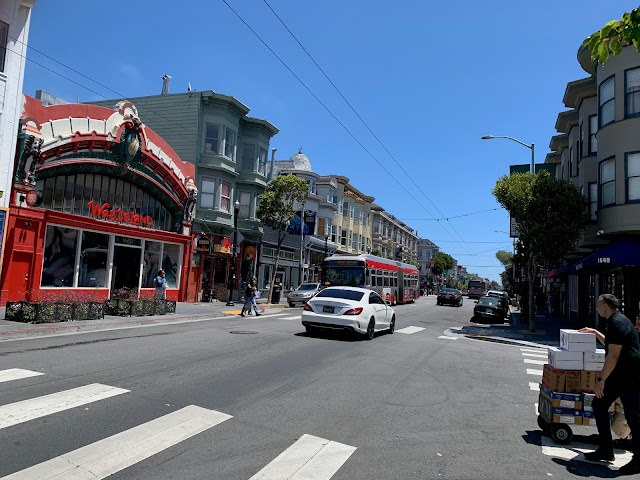
Haight Street, near Ashbury. Unfortunately, the Hippies have long since been gentrified out of this neighborhood.


San Francisco’s “homeless problem” may be overstated by the national media. With the caveat that I did not venture into the Tenderloin, I didn’t see a homeless population in SF any more severe than I might see in Downtown or Midtown Houston. I didn’t have to step over any unhoused person (or their encampments, or their puddles of piss or piles of shit) as I walked along San Francisco’s sidewalks. 

The homeless people that I did see generally kept to themselves and did not accost us for spare change or otherwise make us feel uncomfortable.
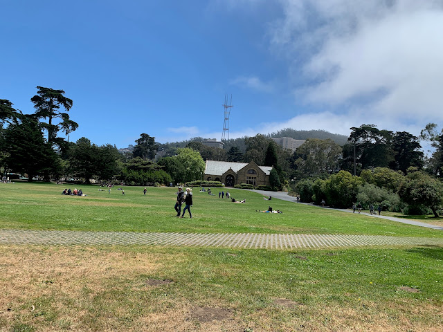
Robin Williams Meadow in Golden Gate Park, with Sharon Art Studio and Sutro Tower in the distance. 


There were, however, signs everywhere around the city warning people not to leave valuables in the their cars. And I noticed that at least one large chain clothing store on Market Street had a line of people waiting to enter; security guards were limiting the number of people who could be in the store at one time, presumably to combat shoplifting.

These were indicators that San Francisco does indeed have a property crime problem that the city is trying to battle. But, as tourists, Corinne and I never felt unsafe anywhere we went.


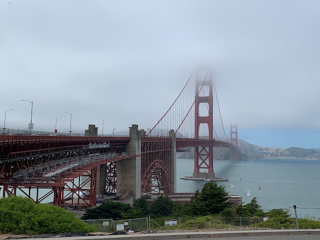
Golden Gate Bridge, as seen from the Visitor's Center on its south end, partially shrouded in fog.


"You just have to see it in person” is a cliché, but in the case of the Golden Gate Bridge, it’s true. I have seen pictures, videos, and movies of the bridge for my entire life, but none of them do it justice. It's hard to appreciate just how big and impressive it is until you've seen it for yourself with your own eyes.  

The bridge, which connects San Francisco with Marin County to the north, opened in 1937.
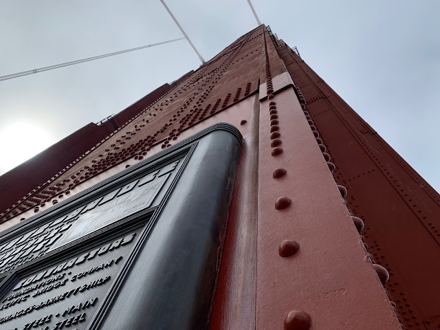
The south tower of Golden Gate Bridge, which rises to a height of 746 feet.


It is possible to bike or walk all the way across the bridge; in fact, we saw people jogging across it. Corinne and I only went as far as the south tower, but we were still treated to a magnificent view of the bay, Alcatraz, and the city. It was cold and windy on the bridge itself, but downtown San Francisco, off in the distance, was bathed in bright sunlight. The city's weather is famously interesting.

The entrance to Fisherman's Wharf. We didn't make it down to Pier 39 to see the sea lions, but we did go to Ghirardelli Square for some chocolate and a beer, so we did a few of the touristy things.


There are so many good seafood restaurants here in Houston. But, respectfully, none of them do crab cakes like they do in Fisherman’s Wharf. Those were surreally delicious. 

In fact, every meal we had in San Francisco, from lunch at a French cafe in Height/Ashbury to dinner at a Thai restaurant in The Castro, was excellent. We weren't in San Francisco long enough to even scratch the surface of all the different cuisines the city has to offer.
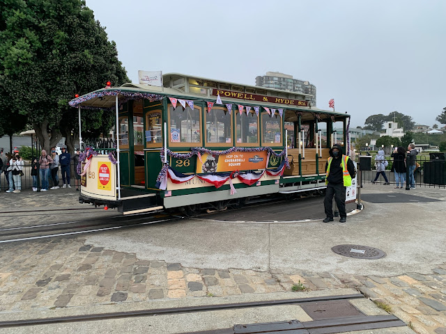
The Powell and Hyde Cable Car turntable near Ghirardelli Square.


We brought the Muni day pass ($5), which allows unlimited rides on buses and light rail for an entire day. This was very convenient for us as we explored the city, although we still did a lot of walking. 

The iconic cable cars are a big tourist draw, and you need a special ticket to ride them (the Muni day pass won't get you on board). We didn't feel like standing in a long line and paying $8 per person just to ride a cable car, but we did have fun watching the cars be manually turned at the end of their route.
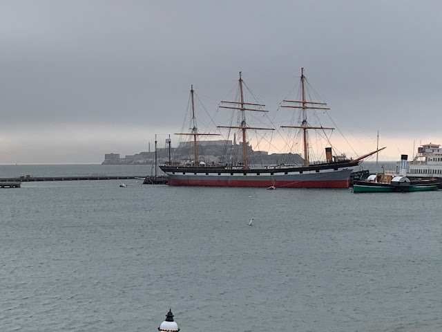
The 1886 rigger Balclutha, with Alcatraz in the background.


As I mentioned previously, San Francisco's weather is famously interesting. During the day, the weather was generally wonderful. Once night fell, however, things got cold rather quickly. "The coldest winter  I ever spent was a summer in San Francisco" may not have been said by Mark Twain, but it's an accurate quote nevertheless.
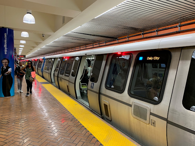
Powell Street BART Station. Along Market Street in downtown San Francisco, MUNI trains run one level below the surface while BART runs two levels below the surface. 


Muni provides transit service in San Francisco itself, while BART (Bay Area Rapid Transit) is a metro system serving the entire Bay Area. Obviously, as a transitgeek I had to take a ride.

As much noterity as the Golden Gate Bridge gets for being an engineering marvel (and it is), the BART Transbay Tube also deserves some recognition. This tunnel, which will celebrate its 50th birthday in just a couple of years, zipped us underneath the Bay from San Francisco to Oakland and back in a matter of minutes. 

Tribune Tower in Downtown Oakland.


The primary purpose of the trip to Oakland was to ride BART; we were in that city just long enough to walk down to Jack London Square and stop in for a drink at a local bar. I was on my best behavior as an Astros fan and refrained from telling A's fans how much their team sucks. 

Jack London Square in downtown Oakland.


The differences in microclimate around the Bay are really amazing. When we took the trip across the bay, it was cold and windy in San Francisco but warm and clear in Oakland. Did I mention that this place has interesting weather?
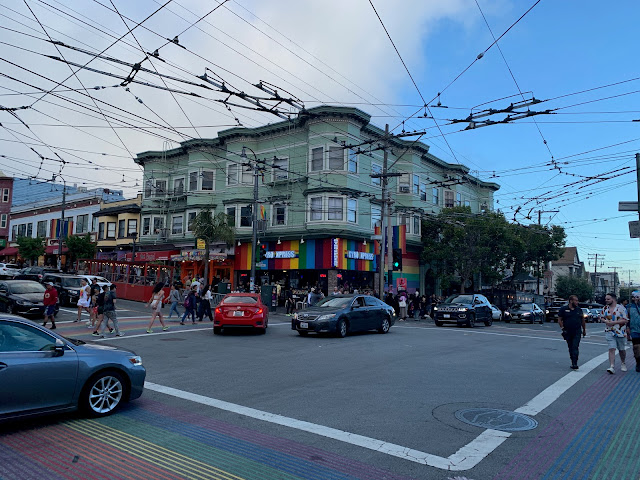
The corner of 18th Street and Castro Street, which is the center of San Francisco's famous "gayborhood." Note the maze of trolleybus catenary wires; the electric motors of Muni's trolleybus fleet handle San Francisco's steep grades better than standard diesel-powered buses. 


Corinne and I have a problem when we travel: we say to ourselves, "let's travel to place X and scratch it off our list of places to see." Then we get there and spend a few days, and realize that there is just so much more to do and see that we have no choice but to return. 

Since we’ve been together, this has been a problem: instead of getting shorter, the travel list keeps getting longer because there are simply so many places we need to return to: Germany, Mexico City, Austria, Venice, Washington DC, Greece, Rome, etc... Now we have to add San Francisco to the list as well. There are entire neighborhoods and attractions - Chinatown, the Embarcadero, the Presidio, Russian Hill, the zoo, Oracle Park, all the museums - that we didn't get a chance to see during our all-too-brief visit.
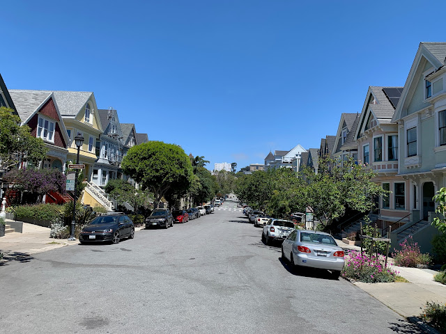
A residential street near Duboce Park.


One final note: Most of what we saw in San Francisco while we walked through it - downtown, Haight/Ashbury, Golden Gate Park, Chrissy Field, Fisherman’s Wharf and the Castro - were normal people doing normal things: hanging out in parks with their kids, fishing off Torpedo Pier, walking their dogs, biking, jogging, having conversations over drinks in outdoor cafes, etc. The city was not a dystopian hellscape.

Does San Francisco have its problems? Yes. Every major city does. However, at a time when this country is horrifically polarized, please do yourself a favor and do not buy into media-driven stereotypes about an entire city.

Thursday, December 30, 2021

Sint Maarten / Saint Martin

Of course it would take me until the end of the year to finish writing a post about a trip I took back in July...

Anyway, last summer's visit to Sint Maarten / Saint Martin - the island is divided between The Netherlands and France, hence the two names - was a "family" affair in that myself, Corinne, Kirby, my mom, my brother and his wife all made the trip. Dad was originally supposed to go, too, but it was only after mom had made the reservation at the timeshare that he realized his passport had expired, and due to significant backlogs in passport processing he was unable to get a new one before the trip. (It was probably for the best, given his mobility issues; he would have had trouble with a lot of the excursions we ended up making.)

This was technically not my first trip to Sint Maarten; it was a port of call on our 2015 Eastern Caribbean cruise and we took a shore excursion to Maho Beach, which is arguably Sint Maarten's most famous tourist attraction, to watch planes land. However, I really didn't spend any time on the island itself, meeting its people or eating its food, until this trip.

While Sint Maarten is technically a semi-autonomous "constituent country" of the Kingdom of the Netherlands, it is culturally Anglo-Caribbean. Saint Martin, on the other hand, is an integral part of France (although English is spoken as much as French and dollars are accepted as readily as Euros). The cars (including my rental) even have standard French plates! This meant that this vacation technically represented my first trip to France, as well.

Neither side if the island is doing particularly well right now; on top of the effect that the pandemic is having on this island's tourist-dependent economy, there are still the lingering effects from Hurricane Irma, which devastated the island in 2017.

Here are some photos of the trip:


The pool area of our timeshare, with Dawn Beach in the distance. Although everything appears fine, if you take a close look at the building to the right you'll see some patches in the walls. It was damaged by Hurricane Irma and is still being repaired. As we traveled around the island we came across innumerable buildings that are still in disrepair, four years after Irma made landfall.  

The courthouse in Philipsburg, which is the capital of (Dutch) Sint Maarten.


Kirby pretends to ignite a (replica) cannon of the Dutch West Indies Company in Philipsburg. The company held the island's trade monopoly during the Dutch colonial era.

An (almost) empty beach in Philipsburg.

Pandemic and Irma in a nutshell: repairs are being made to the jetty in the foreground, while several cruise ships idled by COVID-19's shutdown of the cruise industry, including the Royal Caribbean Rhapsody of the Seas that we sailed on during our trip to Greece a few years ago, are docked at the cruise terminal in the background.

Fort St. Louis overlooks Marigot, the capital of the French side of the island. The fort was originally built in 1789.


A typical Street scene in Marigot, with stores and boutiques and cars with French plates. Driving on this island was an adventure. The roads were narrow and winding, with no left turn bays (which meant a lot of time stopped in traffic while somebody in front of you waited to turn) in . Most major intersections were roundabouts (which I personally don't mind); I only came across one traffic signal on the entire island. Finding parking could also be difficult at times.

Looking down at Marigot from Fort Saint Louis. Before the pandemic, a ferry ran between Marigot and the British island of Anguilla, which would have made for a fun day excursion. Alas...

Kirby poses with the Tricolore atop Fort Saint Louis.

Another (mostly) empty beach. This is Kim Sha beach in Simpson Bay, west of Philipsburg.

The sun sets over Simpson Bay.

Long Beach in Baie Longue. We stopped here on a catamaran excursion, which visited several beaches and snorkeling spots along the southern end of the island.

A view from the catamaran of some of the homes and resorts on Pelican Key, on the Dutch side of the island. 


A cluster of restaurants on Orient Bay, on the French side of the island. We did most of our dining on the French side of the island. The food was excellent! 


Princess Juliana Airport was heavily damaged by Hurricane Irma, and several years later only makeshift repairs have been completed. It was also extremely crowded. 

While we enjoyed the trip, this is the last time I am going to travel internationally until the Coronavirus pandemic is over.* It was a real hassle, and knowing what I know now (articles like this one would have helped me, had I found them ahead of time) I probably wouldn't have done it. The hoops we had to jump through - getting a COVID test within 72 hours of travel, filling out a form on Sint Maarten's website and waiting to receive authorization to travel, purchasing mandatory "COVID insurance” on that same website, printing everything out so that test results and travel authorizations could be verified both in Miami (where we flew out from) and at Princess Juliana, checking our temperature every morning and reporting it to Sint Maarten health authorities via a special website for tourists - were considerable, and a failure at any point would have doomed the trip. 

We also had to get tested in order to return to the United States, which our timeshare did, for $100 per person, utilizing a "doctor" using an in-home rapid test that miraculously showed everybody as being COVID-negative in a matter of minutes. American Airlines accepted the negative test document he gave all of us when we checked in to fly back home, but the process was shady as hell.

Finally, two personal notes about future travel plans:

  • First, I am not going to take my son on any more trips unless he has his own room with his own bed. His (oftentimes tiresome) teenage surliness aside, it really wasn't fair for him to have to sleep on the pull-out sofa in the living room, next to the kitchen where people woke up early to eat breakfast and talk. It interrupted his sleep and made him grouchy.
  • Second, I am going to try to stick to a minimum of two weeks for vacation. This isn't always easy and calls for me to plan and reserve my vacation time carefully, but one-week vacations are simply too short. You don't feel like you've had any "time off." (To be sure, we did spend a couple of days visiting some of Corinne's friends in Florida before we flew on to Sint Maarten, so this vacation ended up being about a week and a half long. It still felt too short.)

Here's to hoping that there is a light at the end of the tunnel that is the current pandemic, and that everybody can have wonderful vacations in 2022. 

Happy New Year!

*Exclusively domestic travel for family vacations also makes sense, given my father's aforementioned mobility issues. When you travel domestically, you can expect most facilities - airports, hotels, museums, etc. - to abide by ADA regulations. Traveling internationally, you can't always expect such accommodations.